Back to Blog
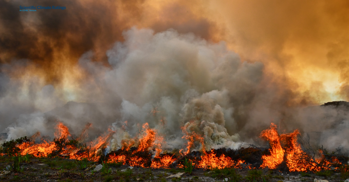
Wildfires have swept across Europe with unprecedented scale, intensity, and unpredictability in the summer of 2025, fuelling concerns that we are entering a new age of fire: the Pyrocene Era.
As the world’s fastest-warming continent, Europe faced its most destructive wildfire season since records began in 2006.
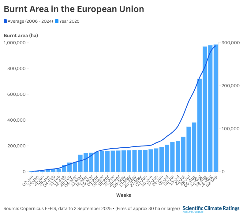
As of September 2, over 986,000 hectares have burned across more than 1,923 fires, up from 227,627 hectares recorded in the same period last year, according to Copernicus European Forest Fire Information System (EFFIS).
Among the most severely affected countries were Greece, Turkey, Spain and Portugal, where fires forced mass evacuations, damaged homes and critical infrastructure and led to mounting economic costs.
While wildfire risks have complex drivers, a clear pattern is emerging: a warming climate leads to more frequent and larger fires, which in turn increase carbon emissions and release the carbon stored in vegetation, reinforcing the warming trend.
Despite the increasing scale of these risks, wildfire exposure and its financial impacts can be assessed, quantified, and mitigated, enabling the implementation of effective adaptation measures.
Scientific Climate Ratings, an EDHEC venture developed by the EDHEC Climate Institute, enables this transition by translating complex data into science-based climate risk ratings and decision-useful financial metrics.
This article examines Europe’s escalating wildfire risks and their links to climate change, and explains how our ratings assess these hazards to empower infrastructure investors and operators.
Tracking the Flames: Europe on Fire
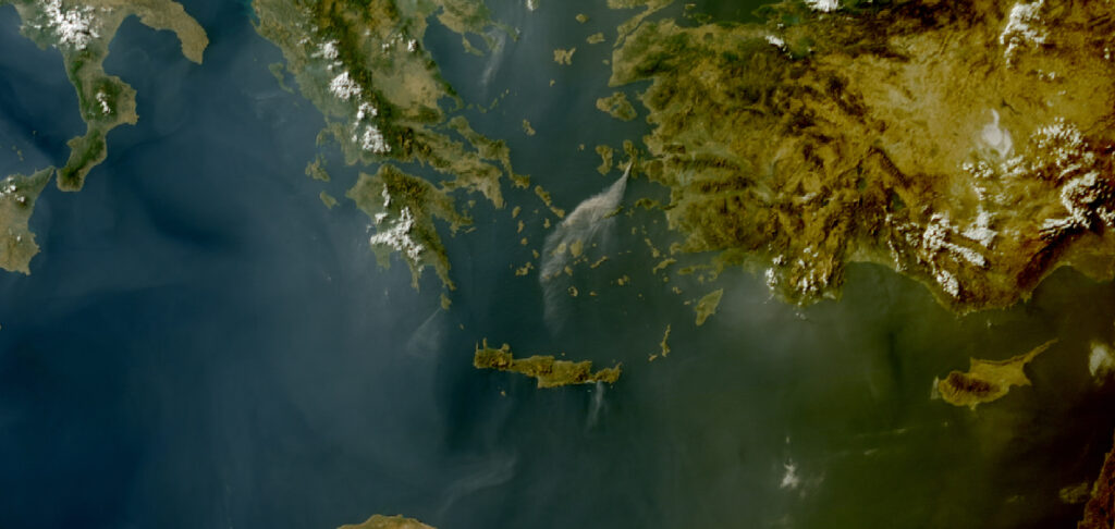
Satellite image showing smoke from large wildfires in Turkey and Greece, July 2025, EUMETSAT
While most of Southern Europe has been literally “on fire”, Greece and Turkey were particularly ravaged since early June, as hotter, drier summers made the Mediterranean region increasingly vulnerable. Both countries had extremely high values of Fire Weather Index (FWI), a meteorologically based index used worldwide to estimate fire danger.
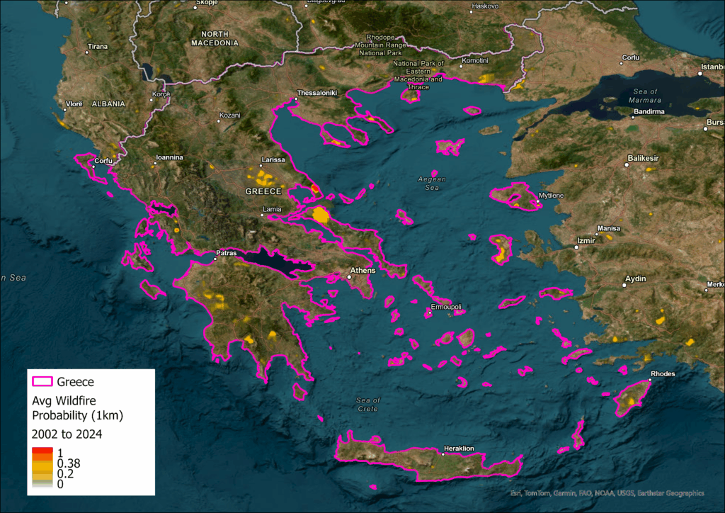
In June and July, massive blazes swept through Greek cities and islands, reaching Chios, Crete (the largest island), west of Athens, Evia, Kythira and Attica, forcing tens of thousands of people to be evacuated from their homes. By August, fast-moving fires in Keratea, Patras, Zakynthos caused significant destruction.
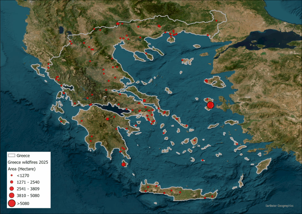
Image: Greece wildfires up to August 2025
As temperatures reached 42.4°C in central Greece, strong winds made it harder to contain blazes, despite earlier measures to reinforce firefighting teams by Greek authorities. The fires destroyed homes and critical infrastructure, also causing power cuts. According to the National Observatory of Athens, by mid-August, approximately 45,000 hectares had burned in the country.
In neighbouring Turkey, several major cities battled extensive fires in the same period. In June, more than 50,000 people were evacuated in the western province of Izmir, near the Aegean Sea, one of the worst-hit cities. Fanned by fierce winds, the fires led to the closure of main roads and a temporary shutdown of the airport, as well as disruptions in water supply and damage to electricity grids.
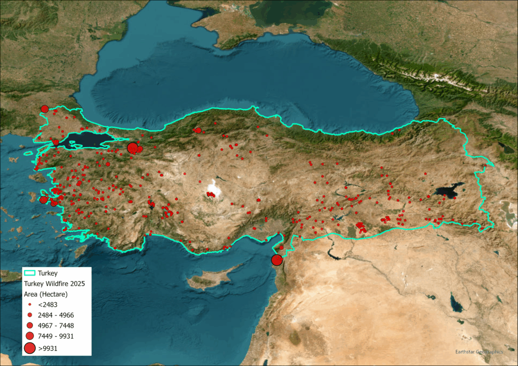
Turkey wildfires up to August 2025
Bursa, Manisa, Bilecik, and Hatay, located in the north and southeast, also experienced mass evacuations. More than 17 people have died, including 10 firefighters and volunteers in the western city of Eskişehir in July. In Çanakkale, the Dardanelles Strait, one of the world’s largest shipping routes, was temporarily shut down in August.
A recent study promptly identified global warming as a key factor. Research by the World Weather Attribution group at Imperial College London indicated that climate change caused by humans made fire-prone conditions in Greece and Turkey “about 10 times more likely”.
While most fires were spread more easily due to the vegetation (highly flammable Calabrian pine) across this region, the blazes sweeping the southeastern cities were also affected by human activities like stubble burning and litter in rural areas.
Other countries in Europe, including Cyprus, France, Germany, Italy, Bulgaria, North Macedonia, Albania, Croatia, Montenegro, and the UK, have also battled major fires.
Most recently, the Iberian Peninsula (comprising Spain and Portugal) experienced record-burnt areas following the heatwave in southern Europe. The worst-affected regions included Castile and Leon, Galicia, Extremadura and Asturias in Spain, and Arganil and Sátão in Portugal.
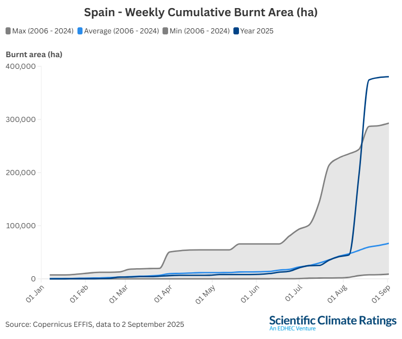
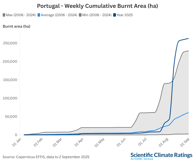
The most recent fires reflect the worrying predictions about future wildfire risks in Europe. Recent data from Copernicus EFFIS shows that the total area burned across the EU has been well above the 2006-2024 average since July, indicating an upward trend driven by climate change.
Several factors are converging to amplify wildfire risk in southern Europe: the abandonment of agricultural land, vegetation overgrowth, and rising temperatures and droughts create ideal conditions for large-scale, high-intensity fires.
However, research highlights that climate change greatly contributes to the growing severity of wildfires.
How is Climate Change Altering Fire Activity?
Wildfires, also known as forest fires or bushfires, are hard-to-control and fast-spreading blazes that occur in vegetation, such as forests, grasslands, and shrublands. They can ignite from small sources like human activity or lightning, or larger causes like volcanic activity. They can rapidly intensify and spread in unfavourable conditions, especially in drier regions. When combined with strong winds, they can leap from tree to tree and consume everything in their path.
Vegetation plays an essential role in wildfires, acting both as a fuel source and a factor that influences fire activity. For instance, sites with dense surface vegetation (such as open areas and rides), flammable species (like bracken, gorse, and eucalyptus), large areas of brash, as well as dead or dying trees, are among the habitats that carry a higher fuel load and pose a greater fire hazard.
While wildfires are nature’s way to clear out dead underbrush and restore nutrients, scientists warn that climate change is driving more intense and frequent fires worldwide.
Global warming is amplifying fire activity by increasing both the likelihood of wildfires, notably through longer fire seasons, and the scale at which they occur. Factors that drive wildfires, such as temperature, soil moisture and the presence of trees, shrubs and other potential fuel, are generally affected by climate change in ways that increase the likelihood of wildfire occurrence and spread.
While vegetation burning is a natural part of the carbon cycle, forests are often promoted as carbon storage solutions, for example, in carbon offsets and credit-related projects. However, their vulnerability to fires undermines their effectiveness as long-term carbon sinks and weakens their role as a natural climate-mitigation strategy. In addition to climate change, land use and forest management also contribute to wildfire risk.
Given the escalating threat, it is crucial to understand how these events are tracked and quantified.
How Can We Monitor and Measure Wildfires?
As fire activity intensifies under a changing climate, the need for accurate and timely monitoring becomes essential. Wildfires are measured using a combination of satellite imagery, ground-based assessments, and geospatial analysis.
One major monitoring platform, The Copernicus Atmosphere Monitoring Service (CAMS), uses near-real-time observations of the location to estimate the emissions through its Global Fire Assimilation System (GFAS). CAMS utilises the fire radiative power (FRP), a measure of heat output from a fire, to address how quickly fuel is being consumed. These observations are derived from sensors that detect the heat signal. Higher values of FRP correspond to higher values of wildfire emissions.
Part of the Copernicus programme, Emergency Management Service (EMS) also comprises EFFIS, a service to protect forests in the European Union (EU) and neighbouring countries.
NASA also monitors wildfires globally using various satellite systems, including the Fire Information for Resource Management System (FIRMS), which identifies the location, extent, and intensity of wildfire activity. The current FIRMS application relies on several sources, including the Moderate Resolution Imaging Spectroradiometer (MODIS) and the Visible Infrared Imaging Radiometer Suite (VIIRS).
The Fire Weather Index (FWI) is the most widely recognised model for assessing fire risks. It accounts for the effects of fuel moisture and wind on fire behaviour and spread. The higher the FWI is, the more favourable the triggering meteorological conditions become. Used daily by fire services and environmental agencies, FWI helps predict fire outbreaks and efficiently allocate resources.
Building on the data collected through wildfire monitoring, Scientific Climate Ratings systematically assesses exposure and quantifies the financial impact of wildfires.
Redefining Wildfire Risk: Accurate, Asset-Level, Financially-Driven Ratings
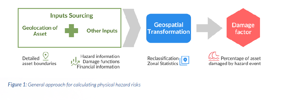
At Scientific Climate Ratings, our methodology developed by the EDHEC Climate Institute evaluates wildfire risks with a stepwise progression. The ratings assess potential physical exposure (through 2035 and 2050 horizons) and quantify the potential damage for each asset.
Our approach takes a step further beyond traditional climate risk assessments by also incorporating financial information for each identified asset (e.g., asset value), along with global climate hazard information, which includes NASA’s global monthly burnt date from 2001 to 2024 (MODIS satellite imagery) and the Fire Weather Index (FWI). We develop our data further to construct a probability map of areas affected by wildfires, representing the current period of 2025.
Map showing average wildfire probability (1 km) between 2002 and 2024 in Greece, EDHEC Climate Institute
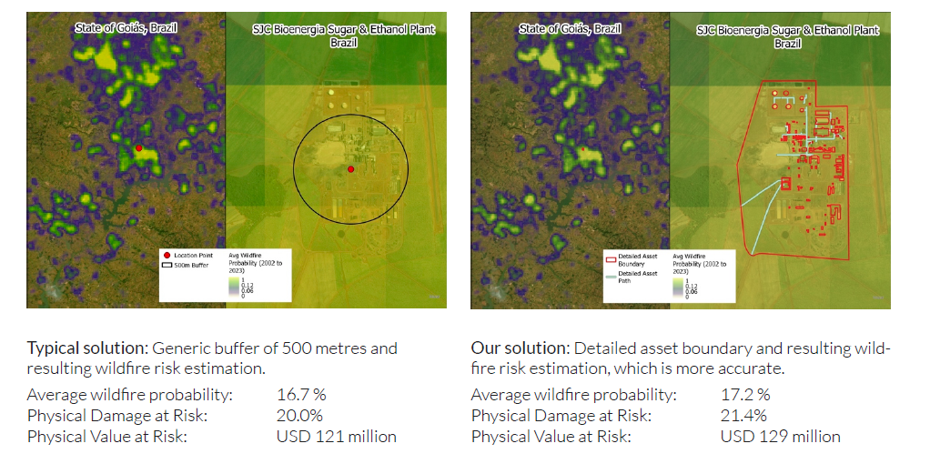
Moreover, our ratings use detailed asset boundaries, which provides more accurate risk estimations compared to generic radius solutions using an approximate buffer. This methodology enables accurate and broadly applicable results, covering various sectors and countries.
We can illustrate this approach in the example of the SJC Bioenergia Sugar & Ethanol plant in Brazil (shown in the figure below). The generic radius approach (on the left) produces an underestimation of wildfire value-at-risk by at least USD 8 million compared to the damage estimations of our detailed asset boundary approach.
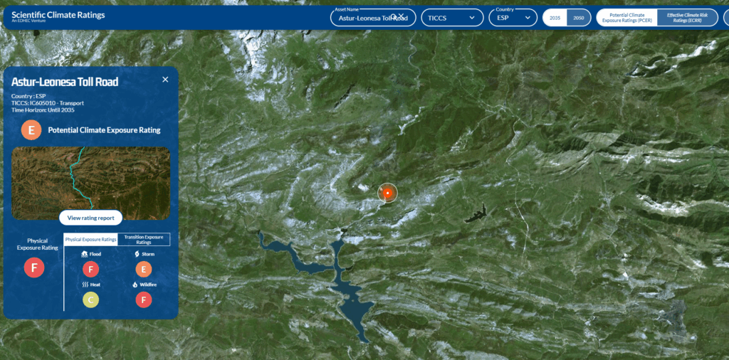
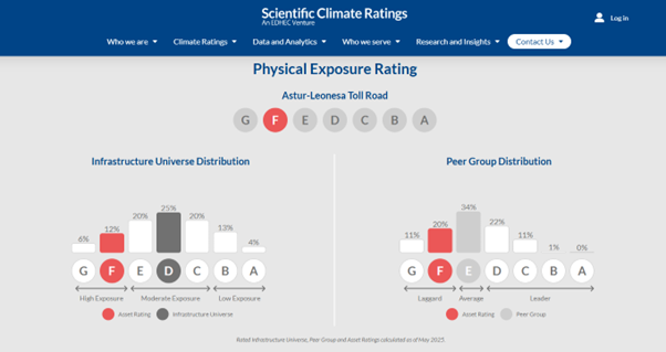
Our Potential Climate Exposure Ratings (PCER) leverages this approach to compute an exposure rating from A (lowest risk) to G (highest risk) for each asset. The example of the Astur-Leonesa Toll Road (AP-66), a critical motorway in Spain between Asturias and the Castilian Meseta, demonstrates its real-world application. Spain is one of the most impacted countries by climate change in southeastern Europe. The Physical Exposure Rating of this transport is rated F, indicating higher wildfire risks.
Wildfires are no longer rare or localised. They are now a systemic and financial risk. With forward-looking, standardised climate risk ratings, Scientific Climate Ratings equips stakeholders to make informed investment and policy decisions to navigate these risks, across Europe and beyond.
Discover our on-demand ratings map, and export the full report and data here: https://scientificratings.com/map/
Learn more about our methodology and download documentation: https://scientificratings.com/data-and-analytics/#physical-risk-data
Reporting and charts: Öykü Altuntaş, Content Producer and Editor, Scientific Climate Ratings
Maps: Qinyu Goh, Sustainability Data Scientist, the EDHEC Climate Institute
Further readings:
Research Database and Insights on Physical Risks, the EDHEC Climate Institute